Tuesday, December 23, 2014

1936 Centennial Grave Marker for Joseph Baker

This is another piece of history to be found at Oakwood Cemetery in Austin, Tx.


Joseph Baker
Born in Maine 1804. Died in Austin, Texas July 11, 1846. One of the founders of “The Telegraph and Texas Register” at San Felipe De Austin, October 10, 1835. A soldier at San Jacinto. First Chief Justice of Bexar County, 1836. Member of the Congress of the Republic, 1837.

Erected 1936 by The State of Texas
Grey Granite Grave marker
Number 14153

More Info:
HMDB.org Page
Handbook of Texas Page
------------------------------------
1936 Marker Hunt 5/1100
------------------------------------

Thursday, December 18, 2014

1936 marker for Woods Fort

Easily found along SH 71 between Smithville and LaGrange


Marker Text:  Site of Woods Fort - Used by colonists of this vicinity as
a protection against Indian attacks
1828-1842
fortified residence of
Zadock Woods
veteran of the War of 1812
One of the old "Three Hundred"
of Austin's colonists
Oldest man killed in the
"Dawson Massacre"
September 18, 1842


Located on SH-71 between LaGrange and Smithville.
Erected 1936
Marker Number 5902
HMDB.org page
------------------------------------
1936 Marker Hunt 4/1100
------------------------------------

Wednesday, December 17, 2014

Travis County 1936 Pink Granite marker

This is one of the 1936 Centennial Markers (pink granite Highway marker)

This one is for Travis County and explains its beginnings.


Located under Mopac at Town Lake
Erected 1936
Marker Number 6447
HMDB.org page
------------------------------------
1936 Marker Hunt 3/1100
------------------------------------

Tuesday, December 16, 2014

Gen. George W. Terrell


Marker Text: Gen. George W. Terrell Born in Kentucky 1803. Came to Texas in 1840 from Mississippi. Associate Justice, supreme court, 1840. Secretary of State, 1841. Attorney General, 1841-42. Charge d'affairs of the Republic of Texas to England, France and Spain 1844-45. Died in Austin, Texas May 17, 1846.

Located near the main entrance to Oakwood Cemetery.
Erected 1936
Marker Number 15113
HMDB.org page
------------------------------------
1936 Marker Hunt 2/1100
------------------------------------

Monday, October 27, 2014

Nativity of the Blessed Virgin Mary Catholic Church


Nativity of the Blessed Virgin Mary Catholic Church is a beautiful church out near Czestochowa and Stockdale in Karnes County.  You can see the church from the main road but the marker is easily missed.  I appreciated the small stone shrine next to the church for a moment of quiet reflection.  The marker number is 12347.

Marker Text: The second Polish colony in Karnes County, the village in this area grew out of a small settlement known as St. Joe and was formally established in 1873.  At times the priest at Panna Maria would conduct services at St. Joseph School in what would become Czestochowa. The "Mother Colony" church at Panna Maria was destroyed by lightning in 1877; Czestochowa settlers decided to build their own church. This was the subject of much controversy among the Polish pioneers of Karnes County. Anton Jarzombek (1836-1922) and Frank Mutz (1814-1891) each donated land for the church. Area residents contributed their labor to build the eighty-five by forty foot church with Gervase Gabrysch (1830-1904) as contractor.  Bishop Anthony D. Pellicer blessed the church on February 10, 1878. Father W. Pelczar was assigned as the first pastor that September.  As a sign of their reconciliation, the parishioners from the newly rebuilt Panna Maria church presented the new parish a large painting of the Virgin Mary of Czestochowa, the Patroness of Poland.  The two congregations often shared leadership in the ensuing years. The Cestohowa church (adopting the Americanized spelling of the community) thrived into the 20th century. In the 1930s the church underwent intensive additions and remodeling. Though the original walls remained, the roof was completely removed and the ceiling raised. The north and south wings were added and the steeple was increased in height.  In 1998, the church celebrated its 125th anniversary. At that time, the parish consisted of 380 members.  The Nativity of the Blessed Virgin Mary Church continues in the traditions of its founders.   (2000)

Tuesday, September 30, 2014

1936 Centennial marker types

There are six major marker types for the 1936 Centennial series:
  1. Museums
  2. Bronze Plaques
  3. Monuments
  4. Pink Granite Highway markers
  5. Grey Granite Historical markers
  6. Grey Granite Grave markers that look just like the Subject markers.
The Texas Historical Commission has a brief document demonstrating these.

Unfortunately their Atlas database which is their authoritative source on-line does not keep it so simple. The field containing the marker type has a large amount of variation and the data could be incomplete or even missing all together.

Here is a list of all the marker types per the Atlas database.

Marker Type Number Of
Missing Information61
14" x 24"2
18" x 12"3
18" x 24"2
18" x 28"9
1936 Centennial3
1936 Centennial (bronze plate)1
1936 Centennial - Grave Marker7
1936 Centennial - Grave Marker (gray granite)51
1936 Centennial - Highway Marker38
1936 Centennial - Highway Marker (pink granite)116
1936 Centennial - Highway Marker (pink granite, bronze plaque)1
1936 Centennial - Monuments and Statues13
1936 Centennial - Subject Marker (gray granite)149
1936 Centennial County Highway Marker1
1936 Centennial Grave Marker1
1936 Centennial Marker115
1936 Centennial Marker (gray granite)177
1936 Centennial Marker (pink granite Highway marker)1
1936 Centennial Marker (pink granite)10
1936 centennial marker; approximately 60" high 36" wide 12" deep1
1936 Highway Marker1
1936 Texas Centennial -- pink granite monument with bronze plaque1
2' diameter disk -independent marker adopted as state marker1
20" x 24" Aluminum Plaque1
24 x 18 Plaque, pink granite highway marker1
27" x 42"10
62" x 34" x 10.5"1
Brass Plate1
Bronze1
C153
Centennial marker2
Centennial marker - brass plaque on small red granite1
centennial marker-large1
Centennial monument5
Centennial-courthouse grounds1
central highway1
Civil War Memorials (pink granite)1
Civil War Memorials - (pink granite)1
Granite Centennial marker1
Grave Marker72
Grave Marker-1936 Centennial4
Gray Centennial Historical marker2
Gray Granite5
gray granite centennial1
Highway1
Highway Marker11
Historical Marker6
Hwy. Marker-1936 centennial1
Large granite3
Large Granite Centennial1
Large granite Centennial Marker1
Medallion Plate1
Memorial1
Monument5
N/A5
other2
Other - explain5
other, 24" x 18"1
Pink centennial highway marker1
Pink Gramte Hwy. marker1
Pink Granite1
Pink granite 19361
Pink granite highway1
Pink granite highway marker11
Pink Granite Hwy. Marker2
Pink highway centennial marker1
Pink Hwy Marker2
Pink Hwy. Marker5
Small centennial marker1
State Approved1
State-approved marker1
statue5
statue monument1
Statue/Monument1
Texas Centennial Commission Monument1
Texas Centennial grave marker1
Texas Centennial monument, pink granite and bronze, 11 feet tall1


Monday, September 29, 2014

Hunt for the 1936 Centennial Markers

I have a new goal.  Hunt down all of the State of Texas 1936 Centennial Markers.

Before there was a historical survey or commission.  1936 became a very big year for historical markers.  Before this, the State of Texas might partner with other groups to memorialize events and places.  So this was the first large scale state sponsored effort.  1936 was huge, it was the 100th anniversary of Texas Independence.  And to commemorate this,  the state legislator chose to create a series of permanent makers in granite that would point out the people, places and events that were important to Texas independence and spread them all across this huge state.

There are 1,100 official markers in 250 of the Texas' 254 counties.

Think of it as a scavenger hunt as big as Texas.

Sunday, September 28, 2014

San Patricio de Hibernia

Not sure if this is considered a Bronze Plaque or a Monument officially. Seems stuck in between to me.  This is one of the 1936 Centennial markers commemorating Texas independence. Even when the light is good, it is hard to take readable photos of these.  The light was particularly bad at this time of the day  because it was coming from behind.  Causing interesting lens flare issues.  The pink granite maker number is 4550.  This location on Main St.(FM 666) in San Patricio is a great place for marker hunters since there are six markers here. 


Marker Text: Founded in 1830 by John McMullen and James McGloin as the seat of their irish colony under an empressario contract dated August 17, 1828 which was fulfilled by the empresarios 1830-1835.  Named in honor of Saint Patrick the Patron Saint of Ireland.  As the frontier outpost of Texas when the revolution began San Patricio 1835-1845 suffered all the miseries of that conflict with no compensating returns.  At and near San Patricio, on February 27, 1836 general Jose Urrea's division of Santa Anna's Army surprised and overwhelmed Johnson's texan party of 35 men, 9 or 10 texans were killed, 6 or 7 escaped and 20 were sent to Matamoros as prisoners.  After San Jacinto the town was destroyed and its inhabitants driven away.  In Memory of Rev. Henry Doyle, Rev. T.J. Molloy, Wm. O'Docharty, Geo. O'Docharty, Walter Henry, Patrick Henry, John Hart, Michael Haley, Mark Killalea, Wm. Hefferman, Oceola Archer, Lewis Ayers, Catherine Hoye, Owen Gaffney, John Ross, Wm. Pugh early settlers of San Patricio.  John McMullen delegate to the consultation, 1835.  John Turner, John White Bower, signers of the Texas Declaration of Independence.  John McGloin, John Fadden, Dennis McGowan, Andrew M. O'Boyle, Geo. Pettuck, Matthew Byrne, Patrick Nevin, Edward Garner, Edward Ryan, Dennis Mahoney, Miles Andross, W.M. Quinn Soldiers in Texas Revolution.  San Patricio has contributed the following distinguished citizens.  Patrick O'Docharty, Susanna O'Docharty, Thomas O'Callaghan, Patrick McGloin, Chris Sullivan, Rose K. Mahoney, John Ryan, Geo. McCowan, Catherine Ryan, James McKeown, Patrick McMurray, Thomas Magowan, Wm. P. Allen, Mary Ann Collins, Hubert Timon, David Odem, John Timon, Andrew Jackson Brown, John Donahue, Mary E. McCloin, Margaret Hart McFall, Patrick Brennan, Margaret Baldeschwiler, John Corrigan, Margaret Q. James, Andrew Gerhardt, Matthew Kivlin, James Grover, Robert Weir, Eliza A. Sullivan, J. Chrys Dougherty, Steve J. Lewis, Joe E. Sullivan, Hugh Touhy, John Dee.


 **Location**
N 27 57'06.045"
W 097 46'22.452"

Main St. (FM 666)
San Patricio
San Patricio
 
Erected 1936

Marker Number 4550

------------------------------------
1936 Marker Hunt 1/1100
------------------------------------

Saturday, September 27, 2014

Saint Patrick's Catholic Church

A very nice church in San Patricio.  I have to admit, most of what I remember is the sticker weeds that were a pain removing from my shoes and pants.  Marker 4476 was erected in 1992 and the church and marker can be found at the corner of Main St. and Magnolia.


Marker Text: Empresarios John McMullen and James McGloin brought irish catholic immigrant families to Texas about 1829 to form a new colony, San Patricio de Hibernia.  Under the direction of the Rev. Henry Doyle, the colonists established Saint Patrick's Catholic Church about 1830.  A fire in 1858 destroyed the original frame church building and all church records.  The Rt. Rev. Jean Marie Odin, first Bishop of Texas, dedicated a replacement church building about 1859.  Local citizens built a two and one half story building for a convent and school on the grounds of Saint Patrick's Church.  After an 1875 hurricane destroyed facilities at Indianola, nuns from the order of Sisters of Mercy relocated in San Patricio and operated Saint Joseph's convent and school from 1876 until 1884.  After a 1919 hurricane completely demolished the church facilities, the congregation rebuilt in 1922.  A need for a larger facility led the congregation to build a fourth structure in 1961.  Through the years Saint Patrick's Catholic Church has served the community with sunday mass and the sacraments and missions given by visiting priests

**Location**
N 27 57'17.409"
W 097 46'18.607

Main St. and Magnoia, San Patricio, San Patricio County
 

Marker Number 4476
 Erected 1992


Wednesday, September 24, 2014

Education in San Patricio

Not all markers are sponsored by government entities or historical associations.  Sponsored by a chapter of The Order of Alhambra, a Catholic charitable organization, this marker tells about early education and church activities in the area.   Erected in 1976 and located on Magnolia in San Patricio, to the left of the marker is Saint Joseph’s Catholic Church and to the right, a cemetery.


Text of the marker:  Education in San Patricio began in 1830 on this site in the picket cabin of Catherine Hoy.  In 1876 Saint Joseph's Convent was erected here.  The Sisters of Mercy, having left Indianola after the Hurricane of 1875, came to run the Mother House and school in San Patricio.  It closed in 1884.  The three story building was razed in 1897 and the lumber was used to build the first Catholic Church in Sinton.  The nuns were Mother Camillus Lucas, Sister Joseph Dunn, Sister Stanislaus Brodrick and six postulants.  Erected July 1976 by Order of The Alhambra Baza Caravan No. 78, Corpus Christi, Texas


Location
N 27 57' 15.645"
W 097 46'13.169"

San Patricio, San Patricio County, Texas

Erected 1976

Old Dougherty House

Old Doughtery House, this marker feels like it is in the middle of nowhere.  However there are 9 other markers near by so this area is rich in Marker Hunting possibilities.  It is a few miles west of Mathis, outside of San Patrcio.  The marker is on a corner near a store with no remnants of the old building to be seen.  Marker number 6342 was erected in 1970. 


Text on Marker:

     Location of noted St. Paul's Academy for Boys.  Home of school owner Robert Dougherty (1827-1881), a refugee from 1840s Irish famine.  Educated at St. Mary's College, Kentucky, Dougherty worked as a journalist and merchant before settling in Texas, here marrying Rachel Sullivan.  In 1867-1874, he was principal, Hidalgo Seminary, Corpus Christi.  Built his school here on Round Lake, near wife's family, 1876.  He taught geography, history, mathematics, Latin, Greek, classical literature and Gaelic--subjects rare in that era.  His seven children all began their careers as teachers.  (1970)

**Location**
N 27 57'20.410"
W 097 46'20.035

**Marker Number**
6342

**Location**   
W. Main and Nopal St., San Patricio, San Patricio County


Tuesday, September 23, 2014

John Howland Wood and Nancy Clark Wood House

Found this on my phone and nearly forgot that I took it. Very random, completely off the beaten track but well worth the effort to find. John Howland Wood and Nancy Clark Wood House is located on the shores of Copano Bay. If you were to turn 180 degrees from where I took this photo you would have an unimpeded view looking over the beautiful waters of the bay. An incredible sight. And this Bayside house was For Sale this summer! That is if you have a couple extra million laying around. Marker Number 12168

Marker Text : John Howland Wood (1816-1904) was born in Dutchess County, New York. Trained in the mercantile trade and apprenticed to a painter, Wood enlisted in the New York Battalion to aid the Texas revolution. He arrived in Texas in 1836 in time to participate in the Battle of San Jacinto and several other major events at the close of the war. Wood settled at Victoria as quartermaster of the Texas Army, marrying Nancy Anna Clark in 1842. They became civic and political leaders and the parents of twelve children. The woods moved to St. Mary's, later called Bayside, where they opened a mercantile business and began to acquire vast land holdings throughout the state while John established himself as a cattleman. In 1849 they purchased this property, establishing a ranch which Nancy Wood dubbed "Bonnie View." Lightning damage to the original house led to the construction of this magnificent edifice on its foundations in 1875. Erected by contractors Viggo Kohler and Hugo Heldenfels, the structure combines a typical Greek revival plan with exuberant high Victorian Italianate detailing. The two-tiered, full-height projecting portico supported by Italianate columns establishes the house's imposing character. The house also features pedimented window surrounds, bracketed eaves and a "widow's walk" or "captain's walk," reflecting the architecture of John Wood's native New York. The house's presence on the rural Texas Coast, where few mansions were built, surely impressed visitors and area residents alike during the post-Civil War era. An outstanding example of the Italianate style, it remains one of the area's most substantial and least-altered country mansions of the period. It was listed on the National Register of Historic Places in 1983. Recorded Texas Historic Landmark - 1998

Monday, September 22, 2014

Site of Old Saint Mary's

At 202 N. St. Mary's Street in San Antonio you can find this piece of history. This has been the  site of St. Mary’s since the early years as a state when they started holding services in 1857. The current church was built in 1924 to replace the older church which had been destroyed in a flood in 1921.  The THC marker number is 15600. 


Marker Text:
After the Texas War for Independence, numerous immigrants, notably from Ireland, Germany, and the Eastern United States, arrived in San Antonio. The need to minister to these non-Hispanic Catholics prompted the Rt. Rev. John M. Odin, first Bishop of Galveston, to establish a separate church for them.   In 1852 land at this site was purchased from the heirs of Ambrocio Rodriguez, a veteran of the Battle of San Jacinto. In 1855 Bishop Odin authorized a building project, undertaken by the Rev. J.M. DuBuis, who became first pastor of St. Mary's Parish and later second Bishop of Galveston. A stately Gothic church building was constructed and opened for worship in mid-1857, serving both English and German-speaking congregations. (In 1869 St. Joseph's Church assumed the ministry for the German Catholics.) On July 1, 1884, the oblates of Mary Immaculate accepted responsibility for St. Mary's, with the Rev. Richard J. Maloney as first oblate pastor.   The old church building was also the site of a seminary, an early free parochial school, the publication of a major Catholic newspaper, and the founding of the St. Vincent de Paul Society.   In 1921 flood irreparably damaged the church building. This Neo-Romanesque structure was dedicated in 1924. (1985) 

Location:
202 N. St. Mary's Street, San Antonio, Tx. 78205


Monday, August 25, 2014

Austin Landmark medallions and plaques

The Historic Landmark Commission is charged with reviewing and granting landmark designations in the City of Austin. But it is the Historic Preservation Office that protects and enhances them.  Many of the properties designated as a Austin Landmark either have a medallion or a plaque identifying the property as such.  The plaques may have a description telling something about the property.

Plaque outside the Paramount Theatre
on Congress Ave.

This medallion was on a building on Congress Ave.

Sunday, August 24, 2014

Now on Instagram!

I now have an account on Instagram where I will posting photos of markers and markings of various types that I come across in my travels.  Look for me as tx_markers

Here is a post I did earlier today:


Sunday, August 10, 2014

Peace Officer Memorial on SH-71

This memorial for Trooper Carlos Warren can be seen going east bound on SH-71 between Austin and Bastrop. The Peace Officer Memorial sign is your warning to slow down if you are interested in taking a closer look. There a small outcropping of pavement right in front of the memorial giving some space to park.

Excerpt from the Officer Down page:
 Trooper Carlos Warren was shot and killed when he interrupted an abduction in progress at a rural highway rest area on Highway 71 near Del Valle, Texas. He was shot in the neck.
 
The Memorial

The plaque reads:
We the people of the State of Texas acknowledge and thank Trooper Carlos Warren for the great sacrifice he made to keep the public safe.  His efforts will stand the test of time.  May God bless his soul.
The Plaque

This sign can be seen east bound on SH-71.

This memorial and tribute was donated by Richard Metcalf. You can find more information about where the markers for Peace Officer Memorials come from on this TxDPS page

Saturday, August 9, 2014

Bastrop

Another photo safari yesterday, this time to Bastrop.  It wasn't the main reason that I went, but I took advantage of the opportunity to take photos of different kinds of markers while I was there.  Weather didn't help since it was about 108 outside.  Wow.

But I came away with several markers along with a few photo jaunts at Bastrop State Park and at a small abandoned gas station along the way.

Only four of the markers that I found Friday around Bastrop

Sunday, August 3, 2014

Camp Mabry

Yesterday I decided to visit Camp Mabry.  Home of Texas' military forces.  What I was looking for was to visit their excellent military history museum and to find five historical markers.  Three of the markers were listed on HMdb.org's Want List. 

I highly recommend the museum if you are in Austin.  It has some great resources about the history of Texas military forces along with a lot of heavy hardware both inside and outside of the museum. We are talking weapons, tanks, airplanes and more. And best of all, it is free!

I was completely successful finding the markers I came to find plus one oddball marker that was behind a fence in an semi abandoned vehicle storage area.

Collage of the five markers I came to find

The strange hidden marker

This has all the trappings of a historical marker.  Made out of sturdy material, such as the granite used here.  State of Texas seal.  But all it has is a list of names of military personnel and dates and it was in a fenced in "junk" area.

Sunday, July 20, 2014

Medallions from the Daughters of The Republic of Texas

I have been coming across some interesting medallions on some of the graves stones of early Texans and have been wondering where they come from.  I have found a source of one with The Daughters of The Republic of Texas.  They have a web page where you can order these and other medallions to be placed at graves, memorials or historical sites of people who lived and were apart of the The Republic of Texas.

Seen on a grave in Bagdad Cemetery


Friday, July 11, 2014

Jefferson Davis Highway Markers


In Austin, I kept passing this marker on South Congress and kept meaning to go back to check it out. Finally did so yesterday and was surprised to see that it is a private marker for the Jefferson Davis Highway and was erected in 1931. That it wasn't on the highway was not too strange. I don't think IH-35 which is a less then a mile away existed in its current form in 1931 so a part of the old route could have come by here.
As seen from South Congress

I have not heard of Jefferson Davis Highway before, nor The United Daughters of the Confederacy. But after a little Googling I was able to find out that the UDC still exists.  The Texas chapter also has a web site and has an excellent page explaining the Texas portion of the Highway and the Markers. They even have photos of all the current markers in Texas, their locations, old brochures and maps. A great find for this (to me) obscure Marker.

 How to find: Marker is located on South Congress Ave, south of William Cannon.

Some additional resources:
Jefferson Davis Memorial Highway in Texas from Texas Chapter of UDC
Map of the Jefferson Davis Memorial Highway from World Digital Library
Photos of the markers in Texas


Sunday, June 29, 2014

Three 1936 State of Texas markers from the Texas State Cemetery

In 1936, the State of Texas erected hundreds of granite monuments across the state. This was before the Texas Historical Commission. There are many in the Texas State Cemetery marking the graves of individuals of historical interest to the State of Texas.  State of Texas Markers 15538, 16098 and 15484 respectively


A soldier of the San Jacinto
Army. Born in South Carolina
1812. Died July 4, 1856.


A veteran of the War of 1812
Internationally famous botanist
Friend of Darwin
Born in Georgia
Died at Long Point
Washington County, Texas
November 28, 1873 


Born in Missouri
1811
Died in Bastrop County, Texas
May 6, 1880
Participated in the
Battle of Gonzales
October 2, 1835
Served in the Texas Army, 1836
and in the Woll Campaign, 1842

Saturday, June 28, 2014

Education in Manchaca

Marker Number 16207,  Erected 2009

Location
Jose Antonio Menchaca Elementary School

Size
27" x 42"

Text
The Community of Manchaca, named for a campsite of Tejano Army Officer Jose Antonio Menchaca. First received a post office in 1851.  Early Educational Efforts included an 1870s subscription school in a one-room frame schoolhouse on Onion Creek. The first public school began in the early 1880s and was held in the Cumberland Presbyterian Church near Onion Creek and adjoining Live Oak Cemetery.  This building was also known as "Old Rock Church," and Professor Alfred H. Decherd was the principal.

The building of the International and Great Northern Railroad tracks through Manchaca in 1881 brought an influx of new settlers and increased economic activity.  In 1883 a new public schoolhouse was built immediately east of this site.  The one-story brick building with bell tower was expanded with a second story in the 1910s.  Which added cafeteria and auditorium space.  The school offered seven grades.  And students went to nearby towns such as Buda for high school education.  Separate schools for African American and Mexican American students operated east and northeast of this site, respectively, beginning early in the 20th century.

The second story of the school was deemed unsafe in the 1950s and was removed, and a new wing of classrooms was added in 1957.  Manchaca schools joined with Oak Hill in 1961 to form a rural high school district, and in the 1960s Manchaca schools became fully integrated. The Austin Independent School District annexed the Manchaca-Oak Hill District in 1967.  Just west of the historic school site, in an area previously known as Dodson's Park, a new school, Jose Antonio Menchaca Elementary School, opened in 1976.


The old school across the street was torn down and is now a church

Friday, June 27, 2014

ANTI-SLAVEHOLDING UNION BAPTIST CHURCH

Text from the Historical Marker:

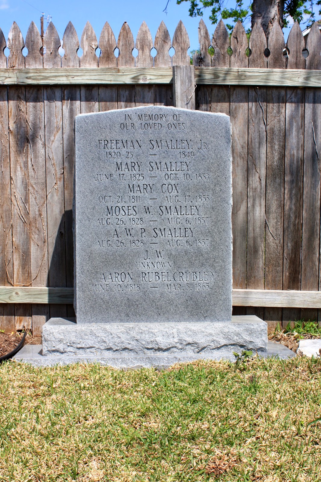
This early Williamson County graveyard has been referred to as the Smalley Cemetery due to its connection with the family of pioneer Baptist preacher Freeman Smalley.  Early settlers of this area, the Smalleys were associated with the nearby Anti-Slaveholding Union Baptist Church.  Though the oldest grave marker is dated 1953, it is believed that Freeman Smalley, Jr. was the first person buried in the cemetery in 1849.  The land on which the cemetery is located was deeded to trustees of the church in 1854.


As the Historical Marker states, the cemetery stone is located down the street to the east.  The stone marking the location can be found on the left hand side next to the house on the corner.  I don't believe this the original grave marker but more a memorial stone raised later.  The entire are where the church and cemetery used to be is now a subdivision.

 Not sure I would want to live on the site of an old cemetery.  Didn't they make a movie about that once?  Poltergeist?


More can be found at HMDB.org

Round Rock, Tx.
GPS: 
N 30.31'  28.406'
W 097 39' 13.491